Photo 1/4


Galerie
Photo 1/4


Vous en avez un à vendre ?
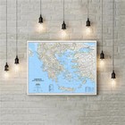
Carte de Grèce National Geographic mur classique stratifié 77x60 cm (30,25x23,5 po)

39,99 USD
Environ34,51 EUR
État :
Neuf
Livre neuf, n'ayant jamais été lu ni utilisé, en parfait état, sans pages manquantes ni endommagées. Consulter l'annonce du vendeur pour avoir plus de détails.
- Achat immédiatCarte de Grèce National Geographic mur classique stratifié 77x60 cm (30,25x23,5 po)
Oops! Looks like we're having trouble connecting to our server.
Refresh your browser window to try again.
Livraison :
36,00 USD (environ 31,07 EUR) Economy Shipping from outside US.
Lieu où se trouve l'objet : Neo Psychiko, Grèce
Délai de livraison :
Estimé entre le mer. 27 août et le mer. 24 sept. à 94104
Retours :
Retours refusés.
Paiements :
Achetez en toute confiance
Le vendeur assume l'entière responsabilité de cette annonce.
Numéro de l'objet eBay :134439421806
Dernière mise à jour le 13 sept. 2023 12:55:10 CEST. Afficher toutes les modificationsAfficher toutes les modifications
Caractéristiques de l'objet
- État
- Region
- World
- Features
- Laminated
- Country/Region of Manufacture
- United States
- ISBN
- 9780792236092
- EAN
- 9780792236092
À propos de ce produit
Product Identifiers
Publisher
National Geographic Maps
ISBN-10
0792236092
ISBN-13
9780792236092
eBay Product ID (ePID)
204355633
Product Key Features
Number of Pages
1 Pages
Publication Name
Greece-National Geographic
Language
English
Publication Year
2022
Subject
Travel, Reference, Science, Earth Sciences / Geography, Europe / General, Atlases, Gazetteers & Maps (See Also Travel / Maps & Road Atlases)
Type
Map
Series
National Geographic Reference Map Ser.
Format
Sheet Map, Rolled
Dimensions
Item Weight
3 Oz
Item Length
23.5 in
Item Width
30.2 in
Additional Product Features
Edition Number
2022
Intended Audience
Trade
Illustrated
Yes
Synopsis
National Geographic's wall map of Greece and the Aegean is one of the largest and most detailed maps of the area. The signature Classic style design uses a bright, easy-to-read color palette and stunning shaded relief. Coverage includes mainland Greece along with areas of bordering Albania, Macedonia, Bulgaria and Turkey. Surrounding waterways, like the Aegean and Ionian Seas are shown with depth curves and soundings along with hundreds of islands, including Crete, Rhodes and Euboea. Also shown are thousands of place names, accurate boundaries, national parks, ruins and major infrastructure networks such as roads, highways, airports, railroads, canals and ferry routes. The map is encapsulated in heavy-duty 1.6 mil laminate which makes the paper much more durable and resistant to the swelling and shrinking caused by changes in humidity. Laminated maps can be framed without the need for glass, so the fames can be much lighter and less expensive. Map Scale = 1:1,494,000 Sheet Size = 30.25" x 23.5", National Geographic's wall map of Greece and the Aegean is one of the largest and most detailed maps of the area. The signature Classic style design uses a bright, easy-to-read color palette and stunning shaded relief. Coverage includes mainland Greece along with areas of bordering Albania, North Macedonia, Bulgaria and Turkey. Surrounding waterways, like the Aegean and Ionian Seas are shown with depth curves and soundings along with hundreds of islands, including Crete, Rhodes and Euboea. Also shown are thousands of place names, accurate boundaries, national parks, ruins and major infrastructure networks such as roads, highways, airports, railroads, canals and ferry routes. The map is encapsulated in heavy-duty 1.6 mil laminate which makes the paper much more durable and resistant to the swelling and shrinking caused by changes in humidity. Laminated maps can be framed without the need for glass, so the frames can be much lighter and less expensive. Map Scale = 1:1,494,000 Sheet Size = 30.25" x 23.5"
Description de l'objet fournie par le vendeur
À propos de ce vendeur
sharkman77
100% d'évaluations positives•113 objets vendus
Inscrit comme vendeur particulierEn conséquence, les droits des consommateurs découlant de la législation européenne ne s'appliquent pas. La Garantie client eBay continue de s'appliquer pour la plupart des achats.
Évaluations du vendeur (57)
- i***a (149)- Évaluations laissées par l'acheteur.6 derniers moisAchat vérifié.
- -***5 (15)- Évaluations laissées par l'acheteur.6 derniers moisAchat vérifiéPreciso.Tutto Perfetto GrazieJacques Cousteau Calypso Metal Pin Vintage Unique (n°134726955046)
- 0***1 (17)- Évaluations laissées par l'acheteur.6 derniers moisAchat vérifiéRecieved with thanks, all went well.Aquatica 8" Removable Dome Shade for wide angle lenses fits all 8” dome ports (n°134345908283)